Tag: Art

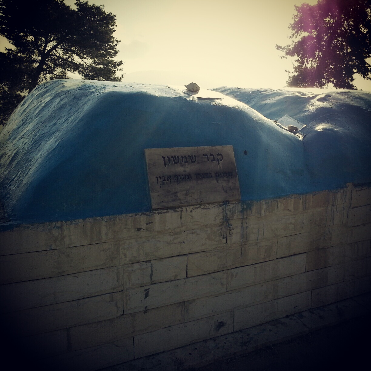
The Biblical Judean Lowlands (Shfela)

After exploring the biblical Negev region on our previous field trip, this week we were staying in the biblical period but moving our focus to the area of the Judean Lowlands (the Shfela, in Hebrew). This is an area of hills and valleys that runs roughly from Mt Hebron westwards until meeting the flat coastal plain. Its main city is Beit Shemesh. In biblical times it was a border area between the tribe of Judah and the Philistines, hence it witnessed quite a lot of tension.

We began our day with a drive through the Tzora forest along the so called ‘Sculpture Trail’. This was a project run by the JNF and encouraged mostly local residents (many new immigrants) to make sculptures in the forest. I don’t think I would particularly go out of my way to see these sculptures in the future, but we did also go up the Tel Tzora (you may recall by now that a Tel is an archaeological mound), where we had a commanding view of the area from which to take our bearings, and where we were able to visit the site traditionally associated with the grave of Samson and his father Manoah.

Samson's Tomb on Tel Tzora
Samson’s Tomb on Tel Tzora

Our guide took this opportunity to regale us with the story of Samson from the bible, which took place in the area of the Judean lowlands, pointing out key sites from the viewpoint. And then some members of the group took the opportunity to visit the tomb which is considered a place to pray for strength.

Sculpture Garden in Beit Shemesh

Continuing our artistic opening to the day, we made a brief stop in the Gan Golan sculpture garden in the historical centre of Beit Shemesh. Golan Peli sadly was killed during the first intifada; his parents were artists and used this space next to their house to create sculptures and place them there in his memory. The sculptures all represent traditional ancient life or stories from the bible. It is a small garden, but if one is in Beit Shemesh anyway, it is a nice place to visit.

Inside the ancient cistern at Tel Beit Shemesh

We pulled out of the modern town of Beit Shemesh and returned to biblical times, visiting Tel Beit Shemesh, the site considered to be the location of the biblical city of the same name. Here we read from the book of Samuel, hearing the story of the Philistine capture of the Ark of the Covenant and its return to the Israelites at Beit Shemesh. Our guide pointed out the route it would have taken as it was brought up to the city on a wagon from the Philistine territory. As part of the excavations they have discovered an ancient cistern and we brought out our torches to have a quick wander inside, which brought a small sense of adventure to our enterprise.

The Israelite fortress from the period of King David at Khirbet Qeiyafa

A short journey down route 38 took us to Khirbet Qeiyafa, another archaeological mound. As recently as 2007 excavators here discovered a fortress in the Israelite style. The site has become important as carbon dating of olive pits unearthed here date the site to the period associated with the rule of King David (although as with most archaeology in Israel, this is majority but not consensus opinion). Various other evidence corroborates that it was a Jewish settlement. This would therefore be an extremely important site; the only site we have from this time period. But it remains fairly unknown to the public; excavations are still taking place and it is not signposted at all from the road. To visit, I recommend finding an appropriate tour guide!

View over the Judean Lowlands (Shfela) from Tel Azeka

Close by we visited another archaeological mound: Tel Azeka, which is in the midst of the Britannia Park, a JNF forest funded by donations from the UK (hurrah for the UK!). We ascended the tel and enjoyed a commanding view of the region. Our guide read to us from the story of David and Goliath and pointed out where various elements of the story took place. There is something very powerful in hearing these stories one grew up with in one’s childhood in situ. One begins to envision the tale taking place before one’s eyes; it becomes much more real.

View over the Judean Lowlands (Shfela) from Tel Lachish

Our final visit was our most southern, Tel Lachish. This site is mentioned a huge amount in biblical and non biblical sources from the time, and was host to a large complex of temples in the Canaanite period and the second most important Judean city in the Israelite period. The Assyrian king Sennacherib laid waste to it on his war campaign in 701 BCE and a relief of his battle is exhibited in the British museum in London. We made do with a copy and our guide explained the details of the battle; we were able to see the ramp that Sennacherib’s troops built in order to go up to and rout the Tel. It was a major victory but Sennacherib did not make it to Jerusalem; the bible says that his troops were struck by a plague; his memoirs say that he returned to defend a Babylonian invasion.

The Israelites did return to Lachish eventually but the city was attacked and destroyed again during Nebuchadnezzar’s invasion in the 6th century BCE. A somewhat unfortunate bunch, it seems. The ruins are extensive and the site also commands an outstanding view of the Judean Lowlands over to the coastal plain. It was with this view in our minds that we returned home to Tel Aviv.

The Lower Galil

The green and hilly region of the Galil in the North of Israel is divided into two, largely based on topography. The Lower Galil is lower in two senses of the word; it is both further to the South and has lower hills (affectionately referred to as mountains in Hebrew).

The Galil is a beautiful place to visit. The rolling green hills make a beautiful backdrop; they are filled with hiking trails. It is also an area of great historical significance. The Galil contains the city of Nazareth, the childhood home of Jesus, and a lot of the miracles he performed took place here. From a Jewish perspective, it became one of the main Jewish centres after the second temple was destroyed; there were several towns here which hosted the Sanhedrin, the Jewish parliament, and indeed the Mishna (Oral Law) was codified in one of these towns, Tzippori.

But neither Tzippori nor Nazareth were the focus of today’s trip. Rather, we were to get an overview of the region. This overview began at Tel Chanaton. A tel is an archaeological mound. This means that it was a dwelling place for man over several centuries, and was destroyed and rebuilt several times. Each time it was rebuilt, the new settlement was constructed on top of the remains of the old one, and the mound grew.

Tel Chanaton was a dwelling place of man from the Bronze age up until the end of the Persian rule in Israel, roughly a period of 3000 years, and then intermittently afterwards. It is mentioned in ancient sources including letters between Canaanite kings and indeed the bible. From our lookout on the tel we learned about the topography and geology of the Galil in addition to the importance of its situation close to several ancient trade routes. It was a place for people to stop off while travelling and restock food and water. In later times it was also used to collect taxes from travellers.

Remains of Crusader Fortress at Tel Hanaton

Israel is full of these mounds and many have been extensively excavated, but Tel Chanaton has not yet. Some excavation has taken place though and you can squeeze into a small tunnel that takes you into the remains of a Crusader fortress that was based here. There is something quite remarkable about being inside it, knowing that it was not originally buried in the earth. It helps understand the other mounds you see, knowing that all the remains were originally like this.

We moved on from the tel to the Muslim Arab village of Kaukab Abu al Hija. This village is named after the great Husam ad-Din Abu al-Hija, a lieutenant of Saladin. He was known as a righteous man, a man of the people, who encouraged good relationships between Jews and Muslims. We heard a couple of the legends of his time in charge of the area.

In more modern times, this village stood out in the area by embracing the arrival of new Jewish villages. While other Arab villages protested, the mayor of Kaukab Abu al Hija argued in favour of the new arrivals saying that they brought with them better infrastructure and services to the area. He participated in cultural festivals that they organised and tried to develop his village for tourism. To this end, it was the first Arab village in Israel to have a ‘tzimmer’ (a sort of boutique BnB retreat) and they also developed a sculpture garden in the 1990s using work from Jewish and Arab artists in Israel.

Sculpture Garden at Kaukab Abu al-Hija

There were many interesting sculptures in the garden, many connected with thoughts and hopes of peace. I found particularly striking the sculpture pictured of flowers of the symbols of the three major faiths against a stunning backdrop. Sadly our guide told us the flower with the Star of David was frequently broken (you could see where it had been restored); and the flower with the cross was torn down after the Pope made a speech a couple of years ago which was understood to have slandered Mohammed. Although this is sad, the encouraging thing is that the village council has consistently restored the sculpture. And hopefully it will endure.

View over Ancient Yodfat

We moved on to a viewpoint over a small hill (not a tel, we were told) which used to house the ancient city of Yodfat, where we heard the story of its demise. When the Jews rebelled against the Romans in 66 AD, the military commander Vespasian was dispatched with his son Titus (of the arch’s fame) to subdue them. He set out into the Galil to destroy Yodfat which was a key centre for the rebels, under the command of man called Yosef ben Mattityahu. The Romans broke the city walls after 47 days; most of the town had committed mass suicide but Yosef ben Mattityahu survived. He returned to Rome with Vespasian and latinised his name, taking on the surname of his new mentor. The new Josephus Flavius became the official historian for the Roman empire in this region and his accounts are vital for us today in understanding what took place here under the Romans and indeed in locating important archaeological sites.

Chapel at Lavra Netofa

Our next stop was at the communal village of Hararit, where the inhabitants are followers of Transcendental Meditation and meditate together as a community. We passed through the village though to the fields behind it and to the Lavra Netofa. We heard the story of two Christian monks who came here to live an acetic lifestyle in isolation, with a few followers. They found a Byzantine period cistern which they converted into a small chapel which was beautifully decorated for Christmas. It was incredibly peaceful and calm, and an appropriate setting for the story of the monks. The last of them passed away in 2005 but the chapel and community is now maintained by a group of nuns who moved here on their request for this purpose.

We left Hararit and travelled a short distance to the communal village of Avtaliyon. Here we heard the story of the programme to encourage more Jews to move to the area of the Lower Galil in the 1970s and 1980s. At the time, the traditional founders of new communities, the kibbutz, moshav and youth movements, were waning in their strength and influence. So a new concept, that of the communal village, was created. The idea was that people would form a group based on shared interests; perhaps it would be Transcendental Meditation, as in Hararit. There were other new communities created by graduates of the Technion, or employees of Rafael. These communities have remained small but now exist in the Galil and all over the country. Our guide argued that they had helped transform the Galil into an area not known for a good standard of living to an area with a good lifestyle, good education and good employment.

Oil Press at Avtaliyon

Here, we also learned about the manufacture of olive oil. 90% of olive oil in Israel comes from the Lower Galil. It is all made in the Arab villages except for in Avtaliyon, were they have their own press. Sadly, there was no time for tastings; a return visit is probably warranted.

Our final destination was the Muslim Arab village of Deir Hanna. The Arabic name translates as Monastery of John the Baptist, as a tradition says that he was born there. It is a large Muslim village with the ruins of an 18th century fortress at its centre. The visited the fortress and heard the story of its ruler, a local Sheikh called Daher el Omar who stood up against the Ottoman rulers, making himself an intermediary in their tax collection, and while doing so transformed the Galil region. There was barely a place around here that he did not influence, for example he built the city walls in Tiberias, in Akko, and even took a small village called Haifa, fortified and enlarged it.

Sadly for Daher el Omar, the Ottomans had enough of him after around 50 years and having grown in strength they sent a military force to wipe him out. No one replaced him and the Ottomans remained in full control until WWI.

Traditional Arab Home in Deir Hanna

While in the village we visited a local home where the family hosts tourists and explains to them about traditional Arab culture, accompanied by traditional Arab cuisine (not to be sniffed at!). We learned about the traditional way of living and enjoyed some homemade olives (our course fees did not stretch to baklava and coffee, sadly). As the sun set, the call to prayer sounded around the village, and it was time for us to head home.